|
Friday, May 27, 2011
There is a Slight Chance of Severe Weather TodayThere is a slight risk of severe weather for most of Oklahoma this morning through late tonight. Large hail and damaging
winds will be the primary threats. Here is the SPC Severe Weather Risk Map for today. 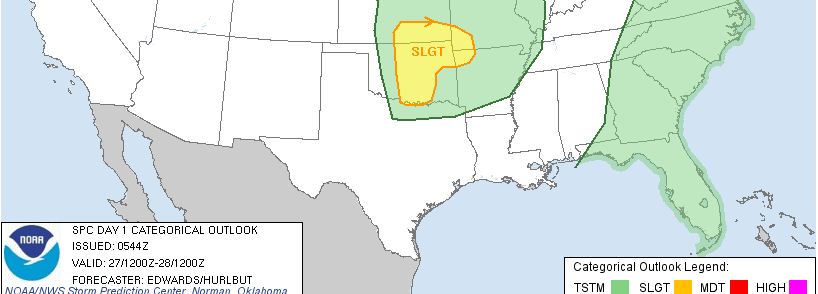 After tonight, look for a hot and humid summer like weekend!
Tuesday, May 24, 2011
PDS Tornado Watch Issued for TulsaLarge damaging tornado’s are on
the ground near Stillwater, Moore, Norman and other cities west of Tulsa. Please tune into your local media and make emergency perpetrations now.
***SEVERE THREAT REAMINS HIGH***
Tue, May 24, 2011 | link
***Threat of Significant Severe Weather Remains High***Storms are expected to begin forming in the next hour west of Oklahoma City. A Particularly
Dangerous Situation Tornado Watch has been issued for areas west of Tulsa. This will expand to cover
all of eastern Oklahoma late this afternoon.
This will expand to cover all of eastern Oklahoma late this afternoon with
storms nearing the Tulsa area by 7:00 PM.
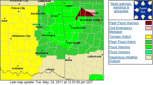 A very small tornado can rapidly become a monster so please take all watches and warnings seriously. The Joplin
tornado went from a small single funnel to a 1/2 mile wide wedge in less than a minute and a half based on some chaser video
that has been released. Again, in this environment today, take all watches and warnings seriously. Here is
the SPC risk map indicating that most of Oklahoma is under a HIGH risk of SIGNIFICANT severe weather. The high risk area has
been expanded eastward since this mornings update. 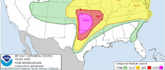 The Tulsa NWS released the public statement below. The Tulsa NWS released the public statement below.
...LONG TRACK VIOLENT TORNADOES POSSIBLE LATER TODAY...
An outbreak of severe thunderstorms is expected across portions
of eastern oklahoma and northwest arkansas later today. The potential For high impact severe weather...including violent long-track tornadoes...is high. Residents across the region should monitor this situation very
closely. Watches and warnings will likely be issued Later today. Have a tornado safety plan in place before severe weather develops and warnings are issued. Stay in
close contact with Family members
and be prepared to take quick action if and when a tornado warning is issued for your area. Persons living in mobile Homes should consider staying with family or
friends that have a more substantial shelter...such as a basement or safe room. Persons May want to consider postponing outdoor activities that are not absolutely
necessary late this afternoon and evening or at The very least be prepared to move to a designated shelter location quickly.
Dangerous Tornado Outbreak Expected Across Parts of OklahomaAll of the ingredients appear to be coming together for a significant and dangerous severe weather outbreak across a good
portion of Central and Eastern Oklahoma.
The current HIGH risk area includes both the Tulsa and Oklahoma City metro
areas.
Here is the current SPC risk graphic:
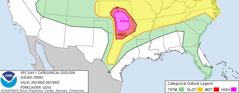
Damaging winds, hail to the size of softballs, tornado's, and strong long track tornado's are possible
in the high risk area.
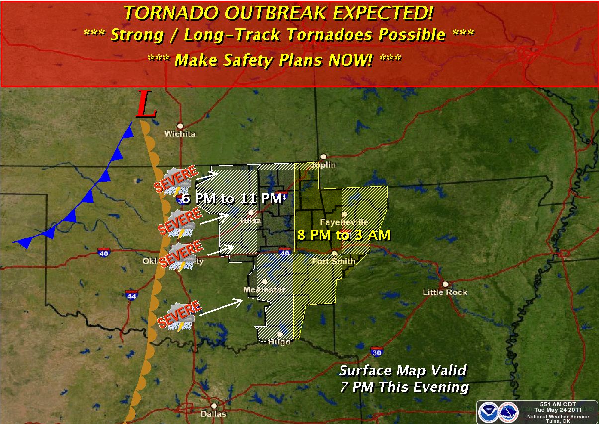
Here is a Tulsa NWS graphic indicating the expected timing of the storms. Currently it appears
the Tulsa area will be affected after 7:00PM at which time some models indicate the atmosphere will be most supportive
of strong tornado's.
There will likely be multiple updates to the forecasts as all weather services are working hard to refine the
forecasts as new data comes in.
There is the potential for this to be an extremely dangerous evening.
Here is a Public Information Statement Issued by the NWS this morning indicating the potential danger this
evening.
Review of severe weather safety rules... An outbreak of severe thunderstorms is expected across portions of Eastern
Oklahoma and northwest Arkansas later today. The potential For
high impact severe weather...including strong long-track Tornadoes...is
high. Residents across the region should monitor This situation very closely.
Watches and warnings will likely be Issued later today. Have a tornado
safety plan in place before Severe weather develops later today. Stay in close
contact with Family members and be prepared to take quick action
if and when a Tornado warning is issued for your area. Here are
some safety Rules to keep in mind when severe weather is expected
or is Occurring.
Before severe weather strikes...ensure that you and your family Are
fully prepared. In a home or building have a pre-designated Shelter...
Such as a basement or an interior room or hallway. Have on hand a disaster supply
kit...including a NOAA weather Radio...flashlight...radio and a good supply of
batteries.
If a severe thunderstorm or
tornado warning is issued...seek shelter Indoors immediately. A severe
thunderstorm is defined as producing Quarter size or greater hail
and wind gusts of 58 mph or more. In Extreme cases...severe thunderstorms
can produce winds to near 150 Mph and hail larger than grapefruits, which can
cause extensive Property damage.
Tornadoes often form very rapidly from severe thunderstorms. If You
are in a tornado watch...and a severe thunderstorm warning is Issued
for your area...monitor local conditions closely and be Ready to take quick action to
save your life.
Remember that lightning is a
thunderstorms most underrated killer. Postpone outdoor activities
if thunderstorms are imminent. This Is the best way to avoid being
caught in a dangerous situation. Automobiles offer good protection
from lightning...although moving Indoors is best. Even inside...lighting
can kill by coming through The phone lines...plumbing and electric lines. Therefore
do not Use computers...telephones or other hand held appliances
during a Storm.
Monday, May 23, 2011
Severe Threat Decreased from Moderate to Slight The overall threat of severe weather has decreased this evening although some severe weather will likely still occur. Here is the latest SPC risk graphic for this evening: 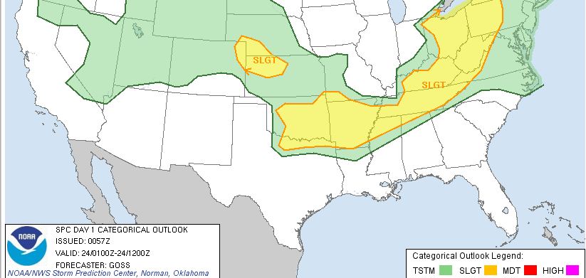 A significant outbreak of severe weather remains likely starting late Tuesday afternoon. 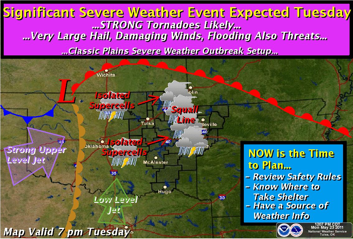
Tornado Watch Issued Until 12:00AMADAIR CHEROKEE
CREEK HASKELL LATIMER
LE FLORE MAYES MCINTOSH
MUSKOGEE OKFUSKEE OKMULGEE
OSAGE PAWNEE PITTSBURG
ROGERS SEQUOYAH TULSA
WAGONER WASHINGTON 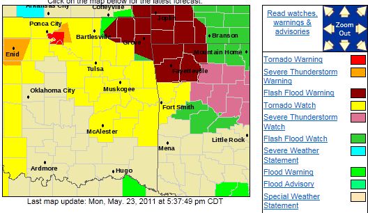 The enhanced tornado threat has also modified some: 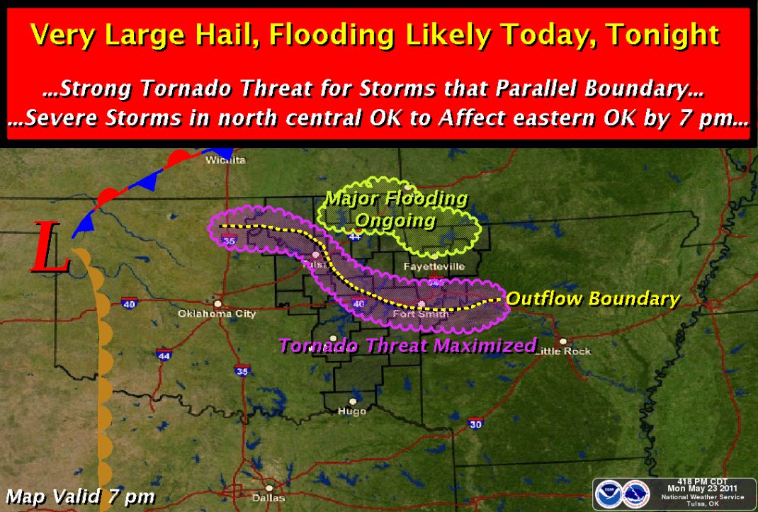
Flash Flood Watch Issued for NE Oklahoma. Severe Threat Remains......FLASH FLOOD WATCH IN EFFECT THROUGH LATE TUESDAY NIGHT... THE NATIONAL WEATHER SERVICE IN TULSA HAS ISSUED A * FLASH FLOOD WATCH FOR PORTIONS OF ARKANSAS AND OKLAHOMA... INCLUDING THE FOLLOWING AREAS...IN ARKANSAS...BENTON... CARROLL...CRAWFORD...FRANKLIN...MADISON...SEBASTIAN AND WASHINGTON. IN OKLAHOMA...ADAIR...CHEROKEE...CRAIG...CREEK... DELAWARE...HASKELL...LATIMER...LE FLORE...MAYES...MCINTOSH... MUSKOGEE...NOWATA...OKFUSKEE...OKMULGEE...OSAGE...OTTAWA... PAWNEE...PITTSBURG...ROGERS...SEQUOYAH...TULSA...WAGONER AND WASHINGTON. 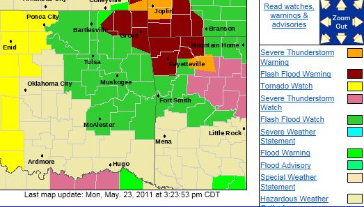 * THROUGH LATE TUESDAY NIGHT * SHOWERS AND THUNDERSTORMS WITH HEAVY RAINFALL WILL CONTINUE
ACROSS PARTS OF FAR NORTHEAST OKLAHOMA AND NORTHWEST ARKANSAS THE REST OF THE DAY...WITH ADDITIONAL STORMS LIKELY
OVERNIGHT ACROSS MUCH OF THE OUTLOOKED AREA. IN ADDITION...THUNDERSTORMS WILL DEVELOP TO OUR WEST
TUESDAY AFTERNOON...AND MOVE ACROSS THE WATCH AREA BY TUESDAY EVENING. * 3 TO 5 INCHES OF RAIN HAS
ALREADY FALLEN ACROSS PORTIONS OF FAR NORTHEASTERN OKLAHOMA AND NORTHWEST ARKANSAS...WITH LOCAL AMOUNTS
OVER 8 INCHES IN CRAIG COUNTY. ADDITIONAL RAINFALL AMOUNTS OF 2 TO 3 INCHES...WITH LOCAL AMOUNTS OF 5 INCHES...WILL BE POSSIBLE THROUGH TUESDAY EVENING. PRECAUTIONARY/PREPAREDNESS ACTIONS... IF YOU ARE IN THE
WATCH AREA...KEEP INFORMED...AND BE READY FOR QUICK ACTION IF FLASH FLOODING IS OBSERVED OR IF A WARNING IS ISSUED. DO NOT DRIVE YOUR VEHICLE INTO AREAS WHERE WATER COVERS THE ROAD TO UNKNOWN DEPTHS. TAKE A DIFFERENT ROUTE
TO REACH YOUR DESTINATION OR WAIT UNTIL THE WATER RECEDES.
Previous update below….
The risk of severe weather remains
this afternoon and evening with an enhanced tornado threat across the Tulsa area. All modes of severe weather are expected
tonight. Here is the latest Tulsa NWS threat map for this afternoon: 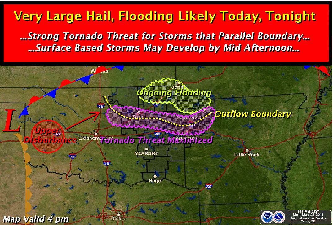 A more significant severe weather event is expected on Tuesday.  Please take the time this to review your families
and your businesses tornado safety procedures. Please take the time this to review your families
and your businesses tornado safety procedures.
Here are some general safety guidelines: Tornado Safety Rules
·
In a home or building, move to a pre-designated shelter,
such as a basement. ·
If an underground shelter is not available, move to
a small interior room or hallway on the lowest floor and get under a sturdy piece of furniture. Put as many walls as possible ·
between you and the outside. ·
Stay away from windows. ·
Get out of automobiles. ·
Do not try to outrun a tornado in your car; instead,
leave it ·
immediately for safe shelter. ·
If caught outside or in a vehicle, lie flat in a nearby
ditch or depression and cover your head with your hands. ·
Be aware of flying debris. Flying debris from tornadoes
causes most fatalities and injuries. ·
Mobile homes, even if tied down, offer little protection
from tornadoes. You should leave a mobile home and go to the lowest floor of a sturdy nearby building or a storm shelter.
Flash Flood Watch Issued for NE Oklahoma. Severe Threat Remains......FLASH FLOOD WATCH IN EFFECT THROUGH LATE TUESDAY NIGHT... THE NATIONAL WEATHER SERVICE IN TULSA HAS ISSUED A * FLASH FLOOD WATCH FOR PORTIONS OF ARKANSAS AND OKLAHOMA... INCLUDING THE FOLLOWING AREAS...IN ARKANSAS...BENTON... CARROLL...CRAWFORD...FRANKLIN...MADISON...SEBASTIAN AND WASHINGTON. IN OKLAHOMA...ADAIR...CHEROKEE...CRAIG...CREEK... DELAWARE...HASKELL...LATIMER...LE FLORE...MAYES...MCINTOSH... MUSKOGEE...NOWATA...OKFUSKEE...OKMULGEE...OSAGE...OTTAWA... PAWNEE...PITTSBURG...ROGERS...SEQUOYAH...TULSA...WAGONER AND WASHINGTON.  * THROUGH LATE TUESDAY NIGHT * SHOWERS AND THUNDERSTORMS WITH HEAVY RAINFALL WILL CONTINUE
ACROSS PARTS OF FAR NORTHEAST OKLAHOMA AND NORTHWEST ARKANSAS THE REST OF THE DAY...WITH ADDITIONAL STORMS LIKELY
OVERNIGHT ACROSS MUCH OF THE OUTLOOKED AREA. IN ADDITION...THUNDERSTORMS WILL DEVELOP TO OUR WEST
TUESDAY AFTERNOON...AND MOVE ACROSS THE WATCH AREA BY TUESDAY EVENING. * 3 TO 5 INCHES OF RAIN HAS
ALREADY FALLEN ACROSS PORTIONS OF FAR NORTHEASTERN OKLAHOMA AND NORTHWEST ARKANSAS...WITH LOCAL AMOUNTS
OVER 8 INCHES IN CRAIG COUNTY. ADDITIONAL RAINFALL AMOUNTS OF 2 TO 3 INCHES...WITH LOCAL AMOUNTS OF 5 INCHES...WILL BE POSSIBLE THROUGH TUESDAY EVENING. PRECAUTIONARY/PREPAREDNESS ACTIONS... IF YOU ARE IN THE
WATCH AREA...KEEP INFORMED...AND BE READY FOR QUICK ACTION IF FLASH FLOODING IS OBSERVED OR IF A WARNING IS ISSUED. DO NOT DRIVE YOUR VEHICLE INTO AREAS WHERE WATER COVERS THE ROAD TO UNKNOWN DEPTHS. TAKE A DIFFERENT ROUTE
TO REACH YOUR DESTINATION OR WAIT UNTIL THE WATER RECEDES. The
risk of severe weather remains this afternoon and evening with an enhanced tornado threat across the Tulsa area. All
modes of severe weather are expected tonight. Here is the latest Tulsa NWS threat map for this afternoon:  A more significant severe weather event is expected on Tuesday.  Please take the time this to review your families
and your businesses tornado safety procedures. Please take the time this to review your families
and your businesses tornado safety procedures.
Here are some general safety guidelines: Tornado Safety Rules
·
In a home or building, move to a pre-designated shelter,
such as a basement. ·
If an underground shelter is not available, move to
a small interior room or hallway on the lowest floor and get under a sturdy piece of furniture. Put as many walls as possible ·
between you and the outside. ·
Stay away from windows. ·
Get out of automobiles. ·
Do not try to outrun a tornado in your car; instead,
leave it ·
immediately for safe shelter. ·
If caught outside or in a vehicle, lie flat in a nearby
ditch or depression and cover your head with your hands. ·
Be aware of flying debris. Flying debris from tornadoes
causes most fatalities and injuries. ·
Mobile homes, even if tied down, offer little protection
from tornadoes. You should leave a mobile home and go to the lowest floor of a sturdy nearby building or a storm shelter.
Moderate Risk of Severe Weather Remains TonightThe risk of severe weather remains this afternoon and evening with an enhanced tornado threat across the Tulsa area. All
modes of severe weather are expected tonight. Here is the latest Tulsa NWS threat map for this afternoon:  A more significant severe weather event is expected on Tuesday.  Please take the time this to review your families
and your businesses tornado safety procedures. Please take the time this to review your families
and your businesses tornado safety procedures.
Here are some general safety guidelines: Tornado Safety Rules
·
In a home or building, move to a pre-designated shelter,
such as a basement. ·
If an underground shelter is not available, move to
a small interior room or hallway on the lowest floor and get under a sturdy piece of furniture. Put as many walls as possible ·
between you and the outside. ·
Stay away from windows. ·
Get out of automobiles. ·
Do not try to outrun a tornado in your car; instead,
leave it ·
immediately for safe shelter. ·
If caught outside or in a vehicle, lie flat in a nearby
ditch or depression and cover your head with your hands. ·
Be aware of flying debris. Flying debris from tornadoes
causes most fatalities and injuries. ·
Mobile homes, even if tied down, offer little protection
from tornadoes. You should leave a mobile home and go to the lowest floor of a sturdy nearby building or a storm shelter.
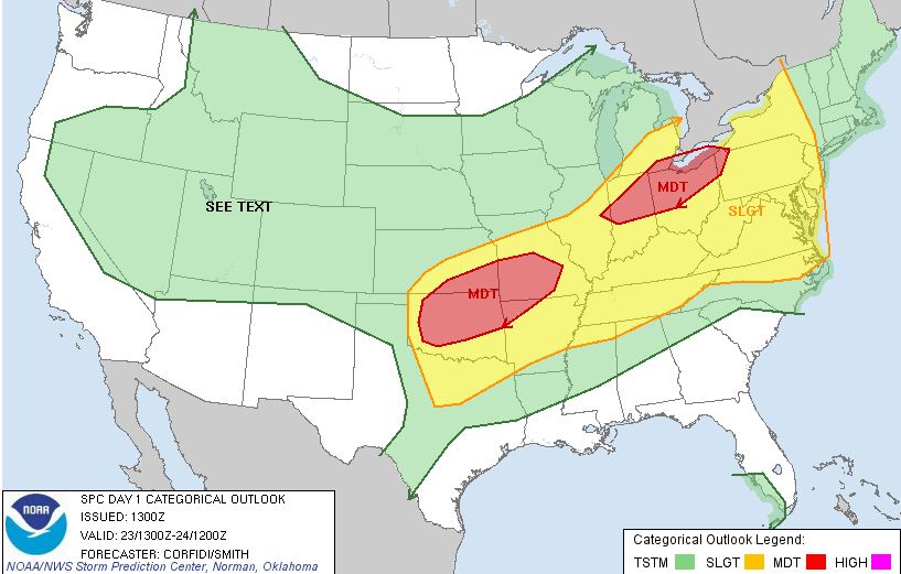
Significant Severe Weather Outbreak Continues Monday Afternoon and Especially on Tuesday There is a moderate risk of severe weather across most of Oklahoma this afternoon and evening.
Here is the SPC
risk map for today:
The severe storms affecting the area this morning are expected to leave boundaries across the area that will interact
with severe storms that form late this afternoon. The areas around these boundaries can expect an enhanced threat of severe
weather late this afternoon.
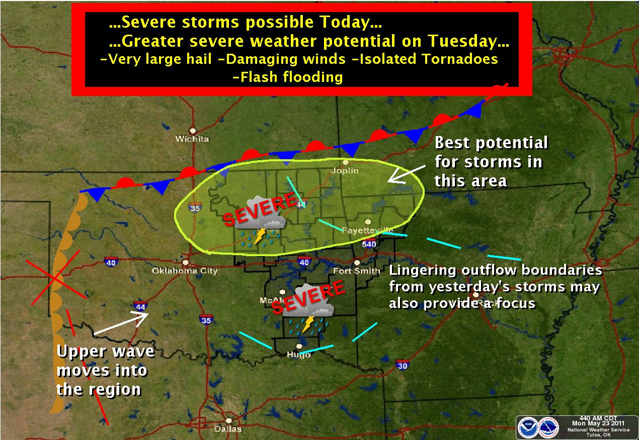
Flash flooding, very large hail, damaging winds, and tornado's are likely late
this afternoon and evening.
Here is a NWS graphic indicating the threats for this afternoon:
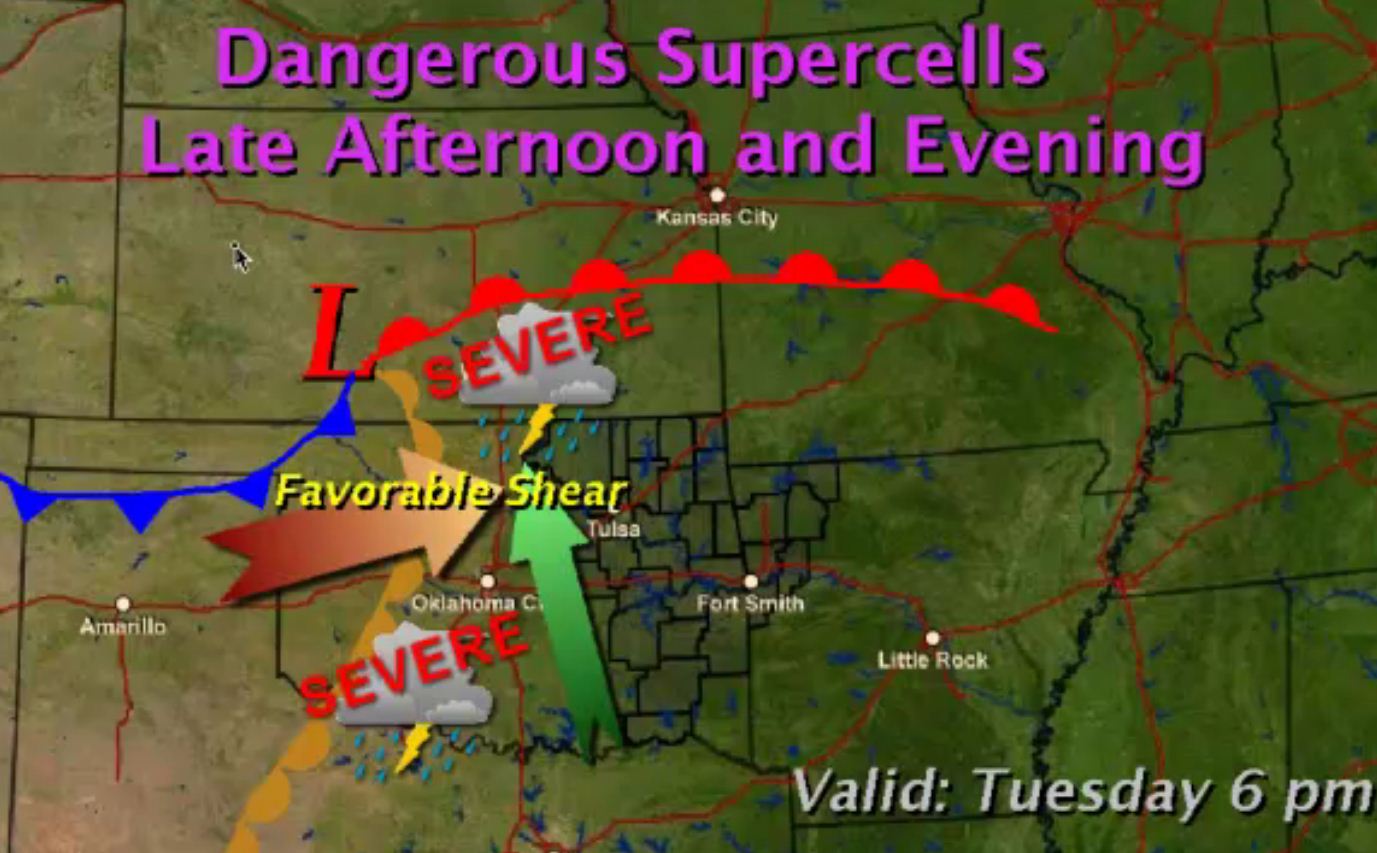
A MAJOR severe weather outbreak is expected across
the area on Tuesday with flash flooding, damaging winds, hail to the size baseballs, and large, long lived violent
tornado's.
Here is an NWS graphic depicting the threats for Tuesday:
Please take the time this morning to review your families and your businesses tornado
safety procedures.
Here are some general safety guidelines:
Tornado Safety Rules
·
In a home or building, move to a pre-designated shelter,
such as a basement. ·
If an underground shelter is not available, move to
a small interior room or hallway on the lowest floor and get under a sturdy piece of furniture. Put as many walls as possible ·
between you and the outside. ·
Stay away from windows. ·
Get out of automobiles. ·
Do not try to outrun a tornado in your car; instead,
leave it ·
immediately for safe shelter. ·
If caught outside or in a vehicle, lie flat in a nearby
ditch or depression and cover your head with your hands. ·
Be aware of flying debris. Flying debris from tornadoes
causes most fatalities and injuries. ·
Mobile homes, even if tied down, offer little protection
from tornadoes. You should leave a mobile home and go to the lowest floor of a sturdy nearby building or a storm shelter.
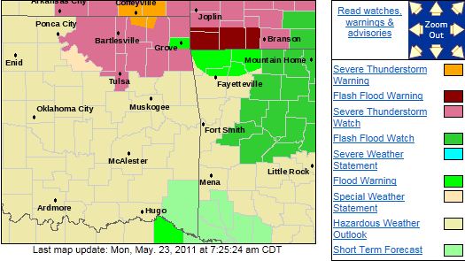
A Severe Thunderstorm Watch has been issued for Tulsa The National Weather Service Has Extended Severe Thunderstorm Watch 337 to Include The Following Areas
Until 1 PM CDT This Afternoon for the following counties:
Craig, Rogers, Delaware, Washington, Mayes, Nowata, Tulsa, Osage, and Ottawa counties.
Large hail and damaging winds are possible with any storms that develop in the area.
Here are
the current NWS watches and warnings:
Sunday, May 22, 2011
Tornado Watch Issued For Most of Eastern OklahomaTORNADO WATCH OUTLINE UPDATE FOR WT 325 NWS STORM PREDICTION CENTER NORMAN OK 130 PM CDT SUN MAY 22 2011 TORNADO WATCH 325 IS IN EFFECT UNTIL 900 PM CDT FOR THE FOLLOWING LOCATIONS OKLAHOMA
COUNTIES INCLUDED ARE: ADAIR
CHEROKEE CHOCTAW CRAIG
CREEK DELAWARE HASKELL
LATIMER LE FLORE MAYES
MCINTOSH MUSKOGEE NOWATA
OKFUSKEE OKMULGEE OSAGE
OTTAWA PAWNEE PITTSBURG
PUSHMATAHA ROGERS SEQUOYAH
TULSA WAGONER WASHINGTON 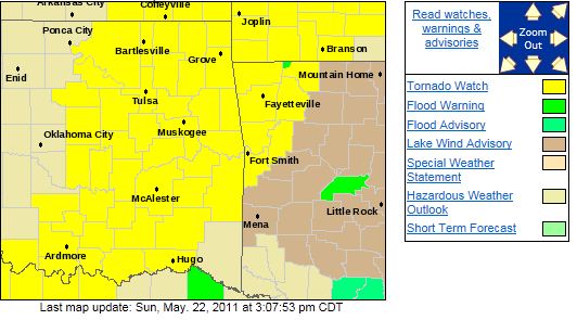
Moderate Risk of Severe Weather This Afternoon and EveningThere is a moderate risk of severe weather for all of NE Oklahoma this afternoon and evening. Large hail, damaging winds,
tornados, and even the possibility for strong tornado's. Storms are expected to fire west of Tulsa late this
afternoon and track across the area. There is a possibility that storms do not form but at this point it appears that they
will and if they do, they will become severe. Here is the SPC severe weather risk map for today: 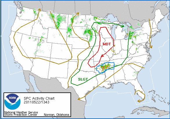
Friday, May 20, 2011
Severe Weather Threat West and ESE of Tulsa TonightDue in part to the rain and clouds sticking around longer than expected, the threat of severe weather in the Tulsa area has
diminished for this evening. There remains a slight risk west of Tulsa and ESE of Tulsa with large hail, damaging
winds, heavy rain, and an isolated tornado in those areas. Thunderstorms remain possible in Tulsa this evening but they
should mostly remain below severe limits. A Flash Flood Watch remains in effect for areas east of Tulsa and a Tornado
Watch is in effect for SE and far eastern Oklahoma this evening. Here is the SPC's severe weather risk
areas for this evening 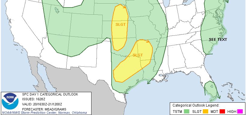
Flash Flood Watch Issued for Areas East of TulsaFLASH FLOOD WATCH IN EFFECT THROUGH SATURDAY MORNING... THE NATIONAL WEATHER SERVICE IN TULSA HAS ISSUED A * FLASH FLOOD WATCH FOR PORTIONS OF ARKANSAS AND OKLAHOMA... INCLUDING THE FOLLOWING AREAS...IN ARKANSAS...BENTON...
CARROLL...CRAWFORD...FRANKLIN...MADISON...SEBASTIAN AND WASHINGTON. IN OKLAHOMA...ADAIR...CHEROKEE...CHOCTAW...CRAIG... DELAWARE...HASKELL...LATIMER...LE FLORE...MAYES...MCINTOSH... MUSKOGEE...NOWATA...OTTAWA...PITTSBURG...PUSHMATAHA...ROGERS... SEQUOYAH AND WAGONER. 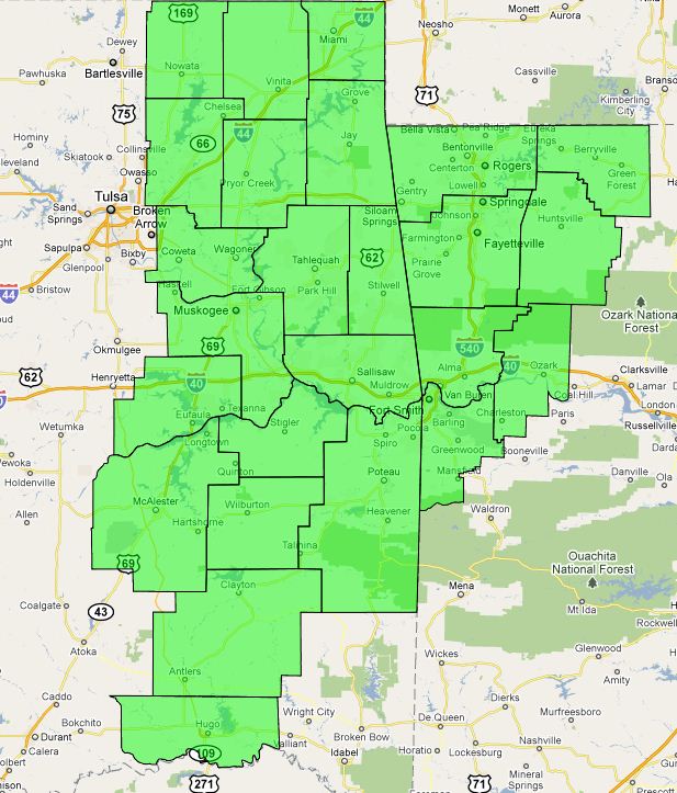 * THROUGH SATURDAY MORNING * SHOWERS AND THUNDERSTORMS WILL CONTINUE TO MOVE SLOWLY EAST ACROSS EASTERN OKLAHOMA AND WESTERN ARKANSAS THE REMAINDER OF THE DAY...WITH ADDITIONAL DEVELOPMENT POSSIBLE
OVERNIGHT. * RAINFALL AMOUNTS OF 1 TO 2 INCHES HAVE ALREADY FALLEN OVER PARTS OF EASTERN OKLAHOMA THIS
MORNING. AN ADDITIONAL 1 TO 3 INCHES OF RAIN IS LIKELY THROUGH TONIGHT...WITH LOCAL AMOUNTS OF 4 TO 6
INCHES POSSIBLE. PRECAUTIONARY/PREPAREDNESS ACTIONS... IF YOU ARE IN THE WATCH AREA...KEEP INFORMED...AND
BE READY FOR QUICK ACTION IF FLASH FLOODING IS OBSERVED OR IF A WARNING IS ISSUED. STAY AWAY FROM DRAINAGE
DITCHES...CREEKS AND OTHER LOW LYING AREAS. THEY ARE PRONE TO RAPID RISES AND MAY FLOOD QUICKLY.
Chance of Severe Weather Remains for Late AfternoonThe storms this morning should move east of Tulsa by early afternoon. Another round of storms is expected late this afternoon
and evening. The severity of these storms depends on how much clearing occurs in the area. If skies clear this
afternoon, the atmosphere will become unstable enough for very large hail, damaging winds, locally heavy rain, and possibly
an isolated tornado. If clearing does not occur, then large hail, damaging winds, and locally heavy rain remain a possibility. Here is an NWS graphic indicating the expected weather today: 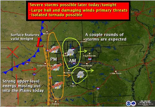 Updates to follow as necessary.
Thursday, May 19, 2011
There is a Slight Chance of Severe Weather on FridayA round of storms is expected to be in the area Friday morning but should mostly stay under severe limits. Friday afternoon
should bring a break in precipitation and allow the atmosphere to destabilize ahead of a line of storms expected late tomorrow
afternoon and evening. This line of storms will likely be severe with large hail, damaging winds, and locally heavy rain possible.
There is a chance of an isolated tornado as well.
More updates in the morning...
Thu, May 19, 2011 | link
Thursday, May 12, 2011
Severe Thunderstorm Watch Issued
Severe Thunderstorm Watch Issued
until 10:00 pm for the areas shaded below.
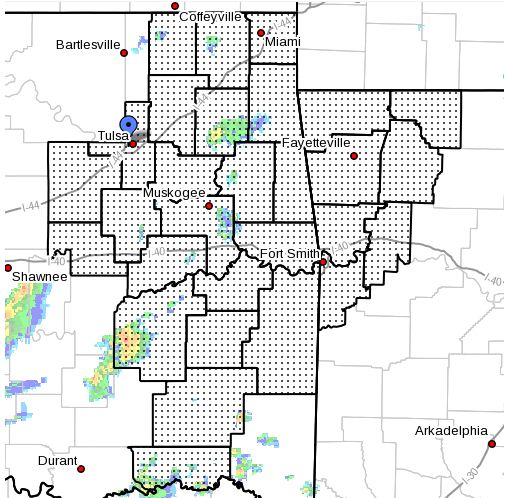
There is a severe thunderstorm warning for Creek county at this time. This storm is moving NE and will likely
effect parts of southern Tulsa county in the next hour or so.
Slight Risk of Severe Weather Late This Afternoon, Mainly East of Highway 169There is a slight of risk of severe across most of Eastern Oklahoma with the greatest threat east of highway 169. Large hail,
damaging winds, and an isolated tornado are possible with these storms. Storms should begin to form around to just
west of Tulsa between 4-6PM. These storms will likely remain below severe limits until they get east of Tulsa. Here
is the SPC Severe Weather Risk Graphic: 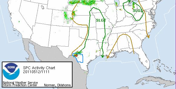 There could be some lingering showers in the area on Friday but they should remain light. Much cooler
weather on tap Friday through Monday with highs in 60's and lows in the 40's.
Wednesday, May 11, 2011
Severe Threat ContinuesHere is a quick update to the severe thunderstorm potential. Severe thunderstorms are on-going across all of central
Oklahoma at this time. This line of storms is expected to continue to move to the NE with the storms SW of Tulsa expected
to begin affecting our area as early as 4:30pm. Here is the latest radar image: 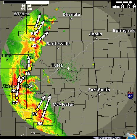 Hail to the size of golfballs and damaging winds could occur in the strongest storms. A severe thunderstorm watch remains in affect for the area through 7:00PM this evening. Here is the current
watch area (in yellow) and I would not be surprised to see the watch extended for a few hours this evening for the Tulsa area
and expanded east into Arkansas as well:  Here is the latest SPC severe weather risk map for our area: 
Severe Thunderstorm Watch IssuedA line of storms currently entering the I-35 corridor in central Oklahoma are expected to intensify as they continue eastward.
These storms could produce large hail and damaging winds but the tornadic threat is very, very low. The cloud
cover and wind fields ahead of this line of storms has limited the overall severe threat. After this round, the atmosphere
is expected to be slow destabilize again thus the tornadic and overall severe threat across NE Oklahoma for today and
tonight has been minimized. Thursday may still bring a round of severe storms, including tornados. Here
is the watch area: 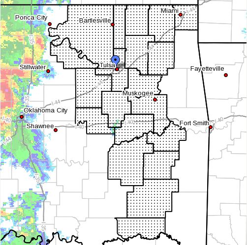 STRONG TO SEVERE THUNDERSTORMS WILL MOVE INTO EASTERN OKLAHOMA EARLY THIS AFTERNOON...AND CONTINUE
EASTWARD INTO NORTHWEST ARKANSAS BY EARLY EVENING. CURRENTLY...INSTABILITY IS HIGH ACROSS THE REGION HOWEVER
WIND SHEAR IS LACKING. THIS WILL PROMOTE ISOLATED CORES OF LARGE HAIL AND STRONG WINDS. LATER THIS EVENING...STORMS
SPREADING NORTHWARD FROM CENTRAL TEXAS MAY ENCOUNTER STRONGER WIND FIELDS TO SUPPORT A LIMITED TORNADIC RISK FOR
SOUTHEAST OKLAHOMA. ADDITIONALLY...PERIODS OF HEAVY RAIN WILL ACCOMPANY THE STORMS AS THEY TRACK EASTWARD THROUGH THE AREA WITH RAINFALL AMOUNTS OF ONE HALF TO ONE INCH LIKELY.
Multiple Rounds of Severe Weather Possible Over the Next 36 hoursThere is the possibility of multiple rounds of severe weather across NE Oklahoma starting as early as this afternoon, this
evening, and possibly again mostly for areas east of Tulsa late Thursday afternoon/evening
Large
hail, damaging winds, and tornados are possible during the next 36 hours.
The exact timing of each round is tough
to determine but weather watches, likely tornado watches, will be issued for the areas most at risk before any of the storms
become tornadic.
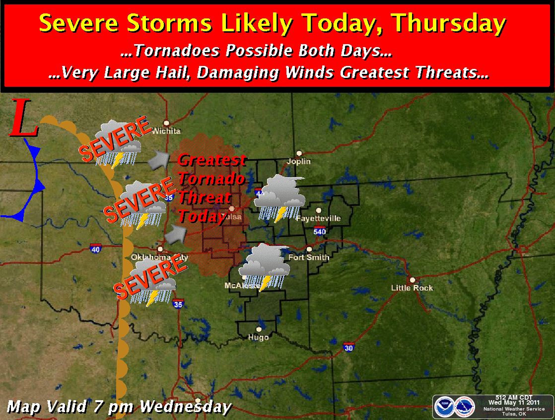
The SPC forecast currently shows the greatest threat of severe weather today across north central
Oklahoma while the Tulsa NWS pulls that area east to roughly highway 69.
Here is the NWS Graphic of the highest
risk area:
Here is an image from simulated radar at 2:00PM today showing the possibility of severe storms in the area.
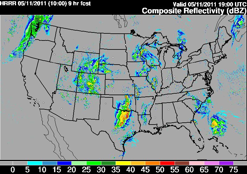
This is a complex situation that the models do not have a good feel for and is allowing for a lot of uncertainty.
I will send out updates as the details become clearer and/or as weather watches are issued by the SPC.
Tuesday, May 10, 2011
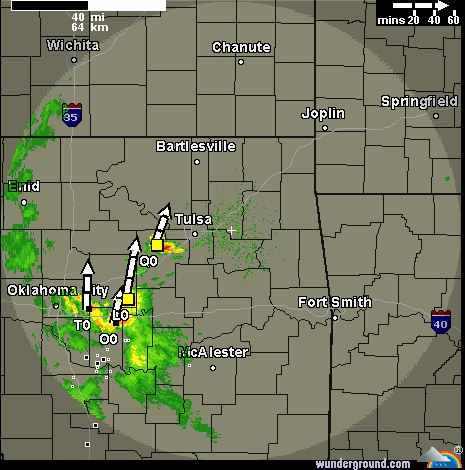
Storms Possible this Evening, Severe Weather Possible Wednesday and ThursdayThunderstorms are forming South and West of Tulsa this afternoon and could impact the Tulsa area. These storms are expected
to mostly remain below severe limits but could pulse up briefly and create some small hail.
Here is the latest
radar image:
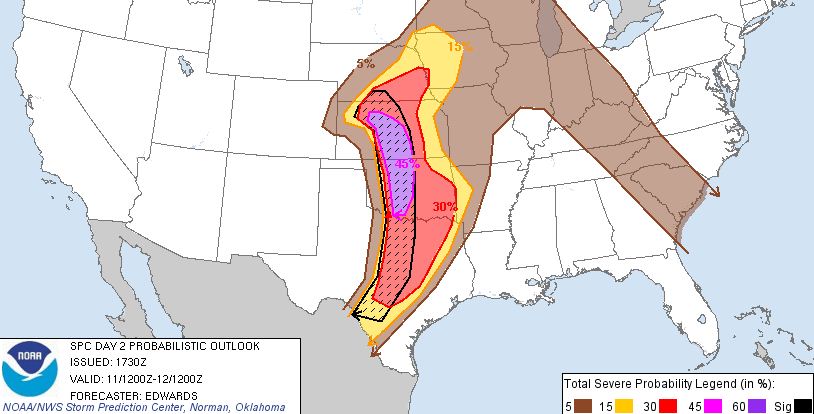
On Wednesday, storms are expected to form along the dryline in Western Oklahoma and track in Eastern Oklahoma
during the early evening hours. Large hail, damaging winds, and an isolated tornado are possible with these storms.
Thursday, a line of storms is expected to form and sweep across the area with large hail and damaging winds being the primary
threat.
Here is the latest SPC risk map for Wednesday:
Updates to follow...
Severe Weather Possible Wednesday and ThursdayThere is a chance of severe weather on Wednesday and Thursday for Eastern Oklahoma. Large hail, damaging winds, and isolated
tornados are possible during this timeframe. Here is the Storm Prediction Centers severe weather risk map for Wednesday: 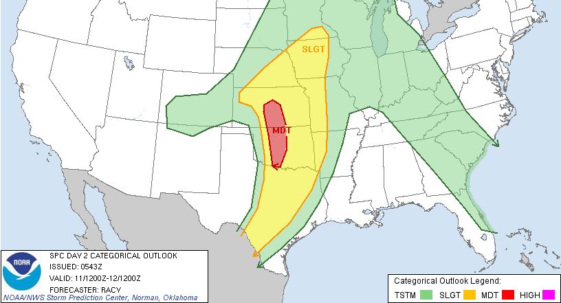 The greatest chances for severe weather across Eastern Oklahoma will be Wednesday afternoon through
early Thursday. Further updates with more specifics will be sent out as more data becomes available.
Monday, May 2, 2011
Frost Advisory Issued for Areas North of I-44, Including TulsaTHE NATIONAL WEATHER SERVICE IN TULSA HAS ISSUED A FROST ADVISORY...WHICH IS IN EFFECT FROM 2 AM TO 9 AM CDT TUESDAY... FOR THE FOLLOWING COUNTIES... * IN OKLAHOMA...PAWNEE...WASHINGTON...OSAGE...CRAIG...NOWATA...
CREEK...OTTAWA...TULSA...ROGERS AND MAYES. 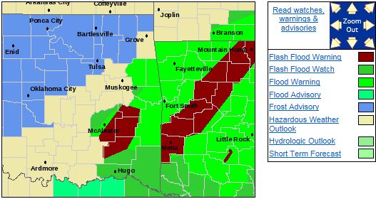 HAZARDOUS WEATHER... * UNSEASONABLY COOL AIR WILL CONTINUE TO MOVE INTO THE AREA...AND
AS THE RAIN AND CLOUD COVER PUSH TO THE EAST THIS EVENING...TEMPERATURES WILL DROP INTO THE MIDDLE 30S ACROSS PORTIONS OF NORTHEAST OKLAHOMA MAINLY ALONG AND NORTH OF THE INTERSTATE 44 CORRIDOR. AREAS
OF FROST WILL BE POSSIBLE DURING THE EARLY MORNING HOURS TUESDAY TO SHORTLY AFTER SUNRISE. IMPACTS... * SENSITIVE OUTDOOR PLANTS MAY BE KILLED IF LEFT UNPROTECTED FROM THE COLD. DEFINITION... * A FROST ADVISORY MEANS THAT FROST IS POSSIBLE.
|