|
Sunday, February 27, 2011
Slight Risk of Severe Weather for the Tulsa AreaThere is a slight risk of severe weather in eastern Oklahoma this evening. Thunderstorms could form along a dryline
in Eastern Oklahoma this evening after 6:00. If they do form, large hail, damaging winds, and tornadoes will be possible.
The latest models are indicating most of the severe weather will remain well to our north in Kansas or to our
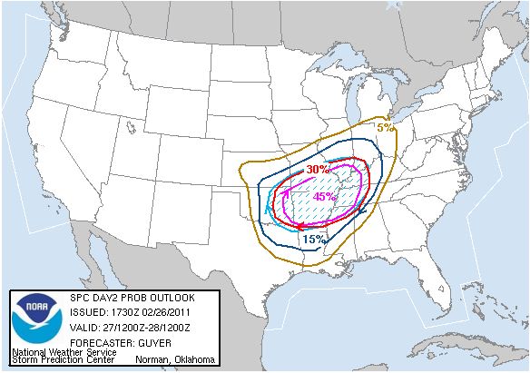
east in Arkansas but I will continue to monitor the situation. Here is the Storm Prediction Center's risk graphic
for today.  Here is the Tulsa NWS severe weather graphic for today. 
Friday, February 25, 2011
Slight to Moderate Severe Weather Risk for SundayThere is a slight risk of severe weather
from Tulsa to the West and a moderate risk from Tulsa to the East. Storms are expected to form along a dry line around I-35
on Sunday afternoon and track to the east. While more isolated, the storms will likely become supercellular and have a high
likelihood of producing large hail, damaging winds, and possibly tornado's.
As the storms progress east through
Tulsa, they will likely line up and come together to form a squall line that will continue to have a high likelihood of large
hail, damaging winds, and possibly tornadoes.
Here is the Storm Prediction Center's Outlook graphic indicating
the area’s most likely to see severe weather.
Thursday, February 24, 2011
FLOOD ADVISORY Issued by Tulsa NWS
FLOOD ADVISORY
NATIONAL WEATHER SERVICE TULSA OK
814 AM CST THU FEB 24 2011
OKC037-113-117-143-241545-
/O.NEW.KTSA.FA.Y.0001.110224T1414Z-110224T1545Z/
/00000.N.ER.000000T0000Z.000000T0000Z.000000T0000Z.OO/
OSAGE
OK-CREEK OK-TULSA OK-PAWNEE OK-
814 AM CST THU FEB 24 2011
THE NATIONAL WEATHER SERVICE IN TULSA HAS ISSUED
AN
* URBAN AND SMALL STREAM FLOOD ADVISORY FOR...
NORTHERN CREEK COUNTY IN NORTHEAST OKLAHOMA
SOUTHEASTERN OSAGE COUNTY IN NORTHEAST OKLAHOMA
PAWNEE COUNTY IN NORTHEAST OKLAHOMA
WESTERN TULSA
COUNTY IN NORTHEAST OKLAHOMA
* UNTIL 945 AM CST
* AT 809 AM CST...DOPPLER RADAR INDICATED THUNDERSTORMS
WITH VERY
HEAVY RAIN 4 MILES SOUTHWEST OF MANNFORD...MOVING NORTHEAST AT 30
MPH.
* LOCATIONS
THAT WILL CONTINUE TO BE AFFECTED BY HEAVY RAIN
INCLUDE...MANNFORD...OSAGE...WESTPORT...SAPULPA...SAND SPRINGS...
GRAY AND TULSA.
PRECAUTIONARY/PREPAREDNESS ACTIONS...
EXCESSIVE RUNOFF FROM THIS STORM WILL
CAUSE FLOODING OF SMALL CREEKS
AND STREAMS...HIGHWAYS AND UNDERPASSES. ADDITIONALLY...COUNTRY ROADS
AND FARMLANDS
ALONG THE BANKS OF CREEKS AND STREAMS AND OTHER LOW
LYING AREAS ARE SUBJECT TO FLOODING.
DO NOT DRIVE YOUR
VEHICLE INTO AREAS WHERE THE WATER COVERS THE
ROADWAY. THE WATER DEPTH MAY BE TOO GREAT TO ALLOW YOUR CAR TO CROSS
SAFELY. VEHICLES CAUGHT IN RISING WATER SHOULD BE ABANDONED QUICKLY.
MOVE TO HIGHER GROUND.
Thu, February 24, 2011 | link
Wednesday, February 23, 2011
Severe Weather Less Likely on Thursday for NE Oklahoma
Wed, February 23, 2011 | link
Tuesday, February 22, 2011
Severe Weather Threat on Thursday
Tue, February 22, 2011 | link
Monday, February 21, 2011
Oklahoma Severe Weather Awareness Week
Mon, February 21, 2011 | link
Thursday, February 10, 2011
More Weather Records Set - All Time Oklahoma Record Low-From the National Weather Service
156 PM CST THU FEB 10 2011
...ALL TIME OKLAHOMA RECORD LOW TEMPERATURE
SET THIS MORNING...
...ALL TIME OKLAHOMA 24 HOUR SNOWFALL RECORD OCCURRED TUESDAY...
THE STRONG WINTER STORM
THAT MOVED THROUGH THE REGION TUESDAY
BROUGHT RECORD SNOWFALL FOLLOWED BY RECORD LOW TEMPERATURES THIS
MORNING
ACROSS EASTERN OKLAHOMA AND NORTHWEST ARKANSAS.
THE OKLAHOMA MESONET STATION A NOWATA REACHED A LOW TEMPERATURE
OF
-31 DEGREES THIS MORNING. PENDING VERIFICATION BY NOAA'S NATIONAL
CLIMATIC DATA CENTER...THAT MARK WILL
ECLIPSE THE PREVIOUS STATEWIDE
RECORD LOW TEMPERATURE OF -27 DEGREES. THE PREVIOUS RECORD LOW WAS
SET AT VINITA
IN FEBRUARY 1905 AND AT WATTS IN JANUARY 1930. THE
MESONET STATIONS ARE MAINTAINED BY THE OKLAHOMA CLIMATOLOGICAL
SURVEY.
NUMEROUS OTHER LOW TEMPERATURE RECORDS WERE BROKEN THIS
MORNING ACROSS OKLAHOMA AND NORTHWEST
ARKANSAS WITH SEVERAL
LOCATIONS DROPPING BELOW THE PREVIOUS OKLAHOMA STATE RECORD.
RECORD LOW TEMPERATURES
READINGS THIS MORNING FROM THE MESONET AND
OTHER SURFACE OBSERVATION SITES IN EASTERN OKLAHOMA AND NORTHWEST
ARKANSAS
INCLUDE:
NOWATA OK -31
PRYOR OK -28
BARTLESVILLE OK -28
BLACKWELL OK -27
FAYETTEVILLE AR -18
TULSA OK -12
MCALESTER OK -4
IN ADDITION TO THE BITTERLY COLD TEMPERATURES...RECORD SNOW FELL
TUESDAY
FEBRUARY 9TH 2011 AS A STRONG WINTER STORM MOVED OVER THE
REGION.
THE SPAVINAW DAM NWS CO-OP SITE
MEASURED 27 INCHES OF SNOWFALL
WEDNESDAY FEBRUARY 9TH 2011 FOR A 24 HOUR PERIOD. PENDING
VERIFICATION BY NOAA'S
NATIONAL CLIMATIC DATA CENTER...THAT SNOWFALL
TOTAL BREAKS THE PREVIOUS 24 HOUR OKLAHOMA STATE RECORD SNOWFALL OF
26 INCHES SET DURING THE MARCH 2009 BLIZZARD AT BOTH FREEDOM AND
WOODWARD.
IN ADDITION...SEVERAL LOCATIONS
ACROSS NORTHWEST ARKANSAS REPORTED
SNOWFALL THAT LIKELY APPROACHED THE ARKANSAS STATE RECORD FOR 24
HOUR SNOWFALL.
BOTH THE RECORD LOW TEMPERATURES AND SNOWFALL FROM THE FEBRUARY 9TH
2011 WINTER STORM ARE PRELIMINARY AND
WILL CONTINUED TO BE
INVESTIGATED BY THE NATIONAL WEATHER SERVICE IN TULSA...THE OKLAHOMA
CLIMATOLOGICAL SURVEY
AND THE NATIONAL CLIMATIC DATA CENTER.
Thu, February 10, 2011 | link
Wednesday, February 9, 2011
Tulsa NWS Reports Snowfall Records Set in Tulsa So Far This SeasonTulsa Snowfall February 8-9, 2011 (see below for Top 5 lists): This storm: 5.7" of storm total snow as of Noon
26.1" of snow this cold season as of Noon
Currently ranks as the number 1 snowiest cold season on record
26.1" of snow this year
as of Noon
Currently ties as 2nd snowiest
year on record
22.5" of snow this February as of Noon
Currently ranks as the number 1 snowiest February on record
Currently ranks as the number 1 snowiest Month on record
Winter Storm Warning Cancelled - Snowfall Totals Coming In
The majority of the snow has ended in most areas and the Winter Storm Warning has been cancelled.
After bitter
cold today and tomorrow, a warm up begins!
Here are some reported snowfall amounts from around the area as of 12:45 that have been reported to
the NWS.
This will be the final update on this event.
IN CHEROKEE COUNTY...
8.00 INCHES OF SNOW 1 MILES EAST OF
TAHLEQUAH
3.00 INCHES OF SNOW AT TAHLEQUAH
IN MUSKOGEE COUNTY...
6.50 INCHES
OF SNOW AT MUSKOGEE
IN OSAGE COUNTY...
18.00 INCHES OF SNOW AT PAWHUSKA
17.00
INCHES OF SNOW 2 MILES SOUTH OF PAWHUSKA
16.00 INCHES OF SNOW AT BURBANK
14.00 INCHES OF SNOW AT FAIRFAX
9.00
INCHES OF SNOW 3 MILES SOUTHWEST OF BARTLESVILLE
8.30 INCHES OF SNOW 5 MILES NORTHWEST OF SPERRY
6.00 INCHES OF
SNOW AT HOMINY
IN PAWNEE COUNTY...
11.00 INCHES OF SNOW AT RALSTON
IN ROGERS COUNTY...
19.00 INCHES OF SNOW 9 MILES NORTHEAST OF CLAREMORE
9.00 INCHES
OF SNOW AT CLAREMORE
8.00 INCHES OF SNOW 6 MILES EAST-NORTHEAST OF OWASSO
8.00 INCHES OF SNOW 3 MILES EAST OF OWASSO
6.00 INCHES OF SNOW AT VERDIGRIS
6.00 INCHES OF SNOW 5 MILES EAST-SOUTHEAST OF OWASSO
4.00 INCHES OF SNOW AT CATOOSA
IN TULSA COUNTY...
8.50 INCHES OF SNOW AT COLLINSVILLE
6.50 INCHES OF SNOW
1 MILES EAST OF OWASSO
6.00 INCHES OF SNOW 5 MILES SOUTH OF BROKEN ARROW
6.00 INCHES OF SNOW 4 MILES SOUTH OF TULSA
5.50 INCHES OF SNOW 4 MILES EAST OF TULSA
5.50 INCHES OF SNOW 4 MILES WEST OF BROKEN ARROW
4.50 INCHES OF SNOW
AT TULSA
3.00 INCHES OF SNOW AT JENKS
IN WAGONER COUNTY...
6.50 INCHES
OF SNOW 5 MILES EAST OF BROKEN ARROW
IN WASHINGTON COUNTY...
16.00 INCHES OF
SNOW AT OCHELATA
14.00 INCHES OF SNOW AT RAMONA
13.00 INCHES OF SNOW AT BARTLESVILLE
12.00 INCHES OF SNOW 1
MILES SOUTH OF COPAN
11.00 INCHES OF SNOW AT COPAN
Wed, February 9, 2011 | link
Snow To End This AfternoonThe snow should continue through the morning and end early this afternoon in Tulsa. It looks like the model that got
the blizzard snowfall amounts and locations correct was closer on this storm than the model I chose but even it was too far
south with the its heavy band of snow as the heaviest snow has been north of Tulsa. With temps being colder throughout
the storm the snow is also much dryer than expected. Roughly 5 inches has fallen so far in Tulsa. Here
are the locations of the heaviest snow per the Tulsa NWS with 15-20 inches of snowfall in the yellow band. 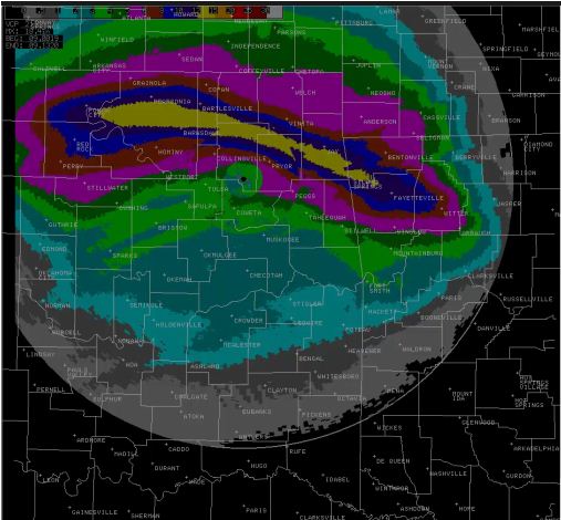 I expect a couple more inches will fall in Tulsa before the snow ends. Once we get through this evening
and Thursday morning things will begin to improve with highs in the upper 20's Thursday and back above freezing on Friday.
Temps will rise to near 60 degrees for highs by next Tuesday.
Tuesday, February 8, 2011
Winter Storm Heading Our WayNo significant changes to the snowfall forecast or timing. Storm is set to begin effecting us this evening. Here are the forecast snowfall amounts and locations. 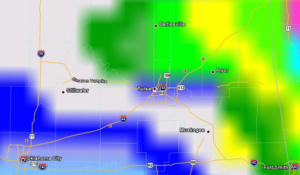  Here is the text of the Winter Storm Warning: URGENT - WINTER WEATHER MESSAGE NATIONAL WEATHER
SERVICE TULSA OK 344 PM CST TUE FEB 8 2011 ARZ001-002-010-011-019-020-029-OKZ049-053>076-090600- /O.EXT.KTSA.WS.W.0005.110209T0000Z-110210T0000Z/ BENTON-CARROLL-WASHINGTON AR-MADISON-CRAWFORD-FRANKLIN-SEBASTIAN- PUSHMATAHA-CHOCTAW-OSAGE-WASHINGTON OK-NOWATA-CRAIG-OTTAWA-PAWNEE- TULSA-ROGERS-MAYES-DELAWARE-CREEK-OKFUSKEE-OKMULGEE-WAGONER-CHEROKEE- ADAIR-MUSKOGEE-MCINTOSH-SEQUOYAH-PITTSBURG-HASKELL-LATIMER-LE
FLORE- 344 PM CST TUE FEB 8 2011 ...WINTER STORM WARNING NOW IN EFFECT UNTIL 6 PM CST WEDNESDAY... THE NATIONAL WEATHER SERVICE IN TULSA HAS ADJUSTED THE TIMING OF THE WINTER STORM WARNING AND IT IS NOW IN EFFECT
UNTIL 6 PM CST WEDNESDAY... FOR THE FOLLOWING COUNTIES... * IN OKLAHOMA...CHEROKEE...ADAIR...CREEK...OKFUSKEE...OKMULGEE...
WAGONER...TULSA...ROGERS...MAYES...DELAWARE...PAWNEE...OTTAWA... PUSHMATAHA...CHOCTAW...WASHINGTON...OSAGE...CRAIG...NOWATA...
PITTSBURG...SEQUOYAH...MCINTOSH...MUSKOGEE...LE FLORE...LATIMER AND HASKELL. IN ARKANSAS...WASHINGTON...MADISON...CRAWFORD... BENTON... SEBASTIAN...CARROLL AND FRANKLIN. HAZARDOUS WEATHER... * A STRONG UPPER STORM SYSTEM
WILL BRING SNOW TO EASTERN OK AND NORTHWEST AR STARTING THIS EVENING AND CONTINUING THROUGH THE DAY
ON WEDNESDAY. THE SNOW WILL BE HEAVY AT TIMES LATE TONIGHT INTO EARLY WEDNESDAY AFTERNOON. *
4 TO 8 INCHES OF SNOW ACCUMULATION WILL BE COMMON ACROSS EASTERN OKLAHOMA...NORTHWEST ARKANSAS AND WEST-CENTRAL
ARKANSAS WITH LOCAL AMOUNTS APPROACHING 12 INCHES. ADDITIONALLY... NORTHERLY WINDS GUSTING
TO 25 MPH WILL PRODUCE BLOWING AND DRIFTING OF THE SNOW. IMPACTS... *
TRAVEL WILL BECOME VERY HAZARDOUS OR IMPOSSIBLE. THE BLOWING AND DRIFTING SNOW WILL HAMPER ROAD CLEARING
EFFORTS. PRECAUTIONARY/PREPAREDNESS ACTIONS... * DELAY TRAVEL AND STAY HOME IF POSSIBLE UNTIL CONDITIONS IMPROVE. * STAY TUNED TO NOAA WEATHER RADIO...COMMERCIAL RADIO OR TELEVISION FOR THE LATEST INFORMATION
CONCERNING THIS WEATHER EVENT. ADDITIONAL WEATHER INFORMATION CAN ALSO BE FOUND AT:
WEATHER.GOV/TULSA.
A Winter Storm Warning Remains in Effect Some light snow could be in the area as early as this afternoon but the heaviest snow should hold off until overnight into
early Wednesday afternoon. This does look to be a heavy wet snow so it should be good for snowmen but bad for roof's which
are already weighed down with snow and water from last week. Here are the snowfall totals I expect. 3-6 generally
from Tulsa to the north and northeast. 6-10 generally in Tulsa and to the west, and 8-12 genrally from Tulsa to
the south and southwest. This could still shift a little to the north and increase the expected snowfall in Tulsa by
1-3 inches as one model still tracks the storm further north.   Temps will stay below through early Friday afternoon with highs only in the teens Wednesday and lows around
0 on Thursday. A quick warm-up will begin Friday with highs in the mid 50's by Sunday and Monday. Here is the text of the on-going Winter Storm Warning:
URGENT - WINTER WEATHER MESSAGE NATIONAL
WEATHER SERVICE TULSA OK 426 AM CST TUE FEB 8 2011 ARZ001-002-010-011-019-020-029-OKZ049-053>076-082200- /O.CON.KTSA.WS.W.0005.110209T0000Z-110210T0300Z/ BENTON-CARROLL-WASHINGTON AR-MADISON-CRAWFORD-FRANKLIN-SEBASTIAN- PUSHMATAHA-CHOCTAW-OSAGE-WASHINGTON OK-NOWATA-CRAIG-OTTAWA-PAWNEE- TULSA-ROGERS-MAYES-DELAWARE-CREEK-OKFUSKEE-OKMULGEE-WAGONER-CHEROKEE- ADAIR-MUSKOGEE-MCINTOSH-SEQUOYAH-PITTSBURG-HASKELL-LATIMER-LE FLORE- 426 AM CST TUE FEB 8 2011 ...WINTER
STORM WARNING REMAINS IN EFFECT FROM 6 PM THIS EVENING TO 9 PM CST WEDNESDAY... A WINTER STORM WARNING IS
IN EFFECT... FOR THE FOLLOWING COUNTIES... * IN OKLAHOMA...CHEROKEE...ADAIR...CREEK...OKFUSKEE...OKMULGEE... WAGONER...TULSA...ROGERS...MAYES...DELAWARE...PAWNEE...OTTAWA... PUSHMATAHA...CHOCTAW...WASHINGTON...OSAGE...CRAIG...NOWATA... PITTSBURG...SEQUOYAH...MCINTOSH...MUSKOGEE...LE FLORE...LATIMER AND HASKELL. IN ARKANSAS...WASHINGTON...MADISON...CRAWFORD... BENTON... SEBASTIAN...CARROLL AND FRANKLIN. HAZARDOUS WEATHER... * A STRONG UPPER STORM SYSTEM
WILL BRING SNOW TO EASTERN OK AND NORTHWEST AR STARTING LATE TODAY AND CONTINUING THROUGH THE DAY
ON WEDNESDAY. THE SNOW WILL BE HEAVY AT TIMES. STRONG WINDS TONIGHT AND EARLY WEDNESDAY OVER PORTIONS OF
NORTHEAST OKLAHOMA MAY RESULT IN SOME BLOWING AND DRIFTING OF SNOW...REDUCING VISIBILITIES. * FROM 4 TO 10 INCHES OF SNOW ACCUMULATION IS EXPECTED FROM 6 PM THIS EVENING TO 9 PM CST WEDNESDAY.
THE LIGHTER AMOUNTS ARE EXPECTED OVER NORTHWEST ARKANSAS...WITH THE HEAVIER AMOUNTS FORECAST
OVER EAST CENTRAL AND SOUTHEAST OKLAHOMA. IMPACTS... * ROADS WILL BECOME SLICK AND HAZARDOUS. THE WEDNESDAY
COMMUTE TO AND FROM WORK WILL BE DIFFICULT TO NEAR IMPOSSIBLE IN SOME AREAS. THE LINGERING
EFFECTS OF THIS SYSTEM MAY IMPACT TRAVEL THROUGH THE END OF THE WEEK. PRECAUTIONARY/PREPAREDNESS
ACTIONS... * DELAY TRAVEL AND STAY HOME IF POSSIBLE UNTIL CONDITIONS IMPROVE. * STAY TUNED TO NOAA WEATHER
RADIO...COMMERCIAL RADIO OR TELEVISION FOR THE LATEST INFORMATION CONCERNING THIS WEATHER
EVENT. ADDITIONAL WEATHER INFORMATION CAN ALSO BE FOUND AT: WEATHER.GOV/TULSA.
Monday, February 7, 2011
Winter Storm Expected to Begin Impacting Tulsa After 7:00 PM TuesdayA Winter Storm Warning remains in effect for virtually the entire state of Oklahoma.
Thinking on
snowfall amounts and locations hasn't changed much but the NWS issued a statement and some timing and model graphics
I thought were very informative. The models are still tracking the storm across essentially three paths. Here
is a NWS graphic of where those paths would place the heaviest snowfall.  The NAM ( in red above) was pretty much dead on for the blizzard for several
days before the storm and the others eventually came into agreement. There has been no agreement yet with this storm
and based on these tracks if the heavier band of snow noted in my early afternoon blog and seen again below changes,
it will likely move to the north. 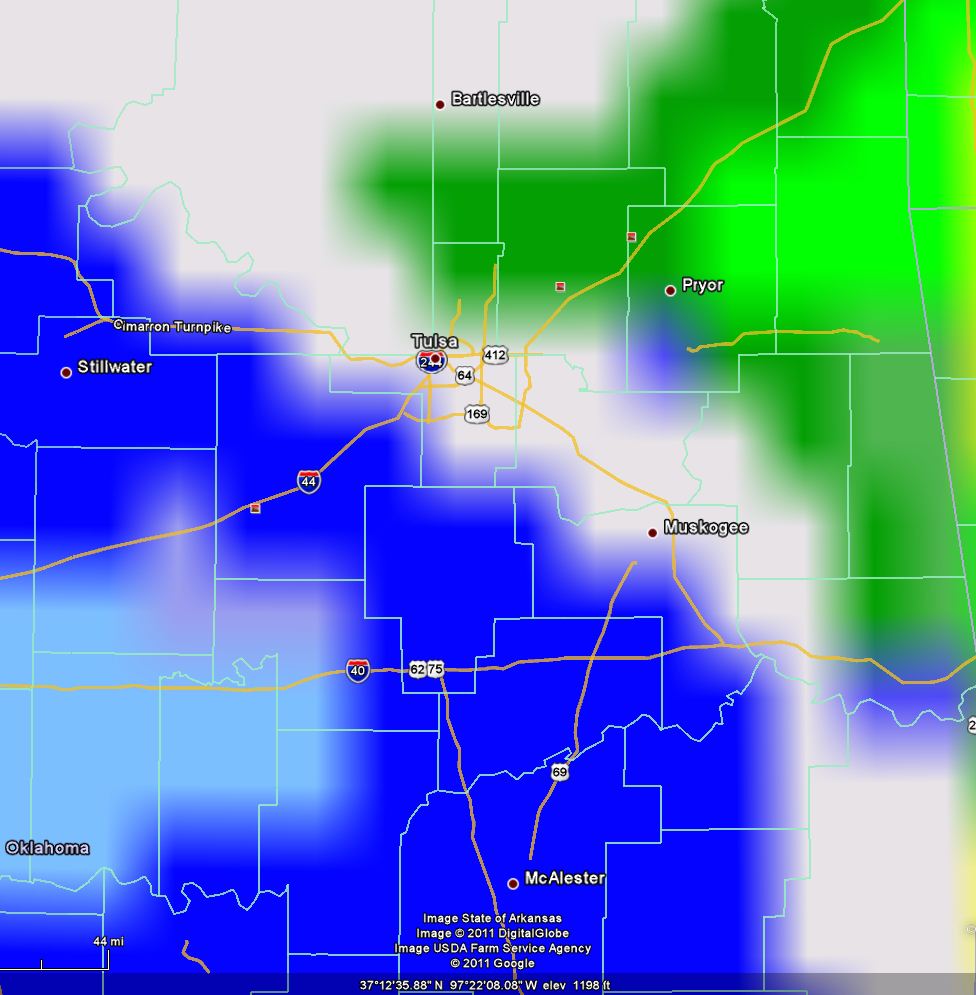  Here is another very nice graphic from the Tulsa NWS indicating the expected timing of the storm across
eastern Oklahoma.  Hopefully the next couple of model runs will give us a better idea of where the heavier snow will fall but
right now, plan on what you see above for your location and stay tuned to all local media for further updates.
Mon, February 7, 2011 | link
Winter Storm Warning IssuedHere are the latest watches and warnings:  Text of the Winter Storm Warming URGENT - WINTER WEATHER MESSAGE
NATIONAL WEATHER SERVICE TULSA OK
321 PM CST MON FEB 7 2011
ARZ001-002-010-011-019-020-029-OKZ049-053>076-080600- /O.UPG.KTSA.WS.A.0004.110209T0000Z-110210T0300Z/ /O.NEW.KTSA.WS.W.0005.110209T0000Z-110210T0300Z/ BENTON-CARROLL-WASHINGTON
AR-MADISON-CRAWFORD-FRANKLIN-SEBASTIAN- PUSHMATAHA-CHOCTAW-OSAGE-WASHINGTON OK-NOWATA-CRAIG-OTTAWA-PAWNEE- TULSA-ROGERS-MAYES-DELAWARE-CREEK-OKFUSKEE-OKMULGEE-WAGONER-CHEROKEE- ADAIR-MUSKOGEE-MCINTOSH-SEQUOYAH-PITTSBURG-HASKELL-LATIMER-LE FLORE- 321 PM CST MON FEB 7 2011 ...WINTER
STORM WARNING IN EFFECT FROM 6 PM TUESDAY TO 9 PM CST WEDNESDAY... THE NATIONAL WEATHER SERVICE IN TULSA HAS
ISSUED A WINTER STORM WARNING FOR HEAVY SNOW...WHICH IS IN EFFECT FROM 6 PM TUESDAY TO 9 PM CST WEDNESDAY... FOR THE FOLLOWING COUNTIES... * IN OKLAHOMA...CHEROKEE...ADAIR...CREEK...OKFUSKEE...OKMULGEE...
WAGONER...TULSA...ROGERS...MAYES...DELAWARE...PAWNEE...OTTAWA... PUSHMATAHA...CHOCTAW...WASHINGTON...OSAGE...CRAIG...NOWATA...
PITTSBURG...SEQUOYAH...MCINTOSH...MUSKOGEE...LE FLORE...LATIMER AND HASKELL. IN ARKANSAS...WASHINGTON...MADISON...CRAWFORD... BENTON... SEBASTIAN...CARROLL AND FRANKLIN. * THIS REPLACES THE WINTER STORM WATCH THAT WAS IN
EFFECT HAZARDOUS WEATHER... * A POWERFUL WEATHER SYSTEM WILL BRING SIGNIFICANT SNOW TO ALL OF
EASTERN OKLAHOMA AND WEST CENTRAL AND NORTHWEST ARKANSAS TUESDAY NIGHT AND WEDNESDAY. SNOW IS EXPECTED TO
BEGIN WEST OF TULSA TUESDAY AFTERNOON...AND SPREAD ACROSS THE AREA TUESDAY NIGHT. SNOW...HEAVY
AT TIMES...WILL CONTINUE WEDNESDAY. NORTHERLY WINDS OF 10 TO 15 MILES AN HOUR...OCCASIONALLY GUSTING TO
25 MILES AN HOUR...WILL CAUSE SOME DRIFTING OF THE SNOW. * FROM 4 TO 10 INCHES OF SNOW ACCUMULATION
IS EXPECTED FROM 6 PM TUESDAY TO 9 PM CST WEDNESDAY. IMPACTS... * TRAVEL WILL BECOME VERY
HAZARDOUS OR IMPOSSIBLE. POWER OUTAGES ARE LIKELY IN SOME AREAS DEFINITION... * A WINTER
STORM WARNING MEANS SIGNIFICANT WINTER WEATHER IS EXPECTED OR IS OCCURRING. GUSTY WINDS ARE ALSO POSSIBLE. PRECAUTIONARY/PREPAREDNESS ACTIONS... * CONSIDER CHANGING TRAVEL PLANS. MAKE SURE YOU HAVE AN ADEQUATE
SUPPLY OF FOOD...WATER AND THE NECESSARY MEDICATION TO LAST THROUGH THE DURATION OF THE WINTER STORM.
* STAY TUNED TO NOAA WEATHER RADIO...COMMERCIAL RADIO OR TELEVISION FOR THE LATEST INFORMATION
CONCERNING THIS WEATHER EVENT. ADDITIONAL WEATHER INFORMATION CAN ALSO BE FOUND AT:
WEATHER.GOV/TULSA.
Winter Storm Path Still in QuestionThe path of the winter storm for Tuesday night and Wednesday remains in question. I am starting to prefer the
snowfall amounts noted below which would bring the heaviest snowfall amounts generally south of a line from Ponca
City to Tulsa to Muskogee. This would put 4-6 inches generally to the NE of Tulsa, 5-9 inches in Tulsa and 8-12 south
of the Ponca City to Tulsa to Muskogee line.   The models are not in very good agreement on the storms track to stay tuned for more updates. Bitterly
cold temps will feed into the area Wednesday with highs near 20 and lows below 0. The weekend is looking very nice
right now with highs expected to be in the 50's with lots of sun!
A Winter Storm Watch Has Been IssuedFrom the National Weather Service in Tulsa
122 AM CST MON FEB 7 2011
...WINTER STORM WATCH IN EFFECT
FROM TUESDAY EVENING THROUGH
WEDNESDAY EVENING...
THE NATIONAL WEATHER SERVICE IN TULSA HAS ISSUED A WINTER
STORM
WATCH FOR HEAVY SNOW...WHICH IS IN EFFECT FROM TUESDAY EVENING
THROUGH WEDNESDAY EVENING...
FOR
THE FOLLOWING COUNTIES...
* IN OKLAHOMA...CHEROKEE...ADAIR...CREEK...OKFUSKEE...OKMULGEE...
WAGONER...TULSA...ROGERS...MAYES...DELAWARE...PAWNEE...OTTAWA...
PUSHMATAHA...CHOCTAW...WASHINGTON...OSAGE...CRAIG...NOWATA...
PITTSBURG...SEQUOYAH...MCINTOSH...MUSKOGEE...LE
FLORE...LATIMER
AND HASKELL. IN ARKANSAS...WASHINGTON...MADISON...CRAWFORD...
BENTON...
SEBASTIAN...CARROLL AND FRANKLIN.
HAZARDOUS WEATHER...
* A POWERFUL WEATHER SYSTEM WILL BRING SIGNIFICANT
SNOW TO ALL OF
EASTERN OKLAHOMA AND WEST CENTRAL AND NORTHWEST ARKANSAS TUESDAY
NIGHT
AND WEDNESDAY. SNOW IS EXPECTED TO BEGIN WEST OF TULSA TUESDAY
AFTERNOON...AND SPREAD ACROSS THE AREA TUESDAY
NIGHT. SNOW...HEAVY
AT TIMES...WILL CONTINUE WEDNESDAY. NORTHERLY WINDS OF 15 TO 20
MILES
AN HOUR...OCCASIONALLY GUSTING TO 30 MILES AN HOUR...WILL
CAUSE SOME DRIFTING OF THE SNOW.
*
FROM 4 TO 10 INCHES OF SNOWFALL IS EXPECTED BEFORE THE SNOW
TAPERS OFF TO OCCASIONAL FLURRIES WEDNESDAY
EVENING.
IMPACTS...
* ROADS...MAY BECOME IMPASSABLE...ESPECIALLY NEIGHBORHOOD ROADS
WHERE
SNOW FROM THE LAST STORM IS STILL CAUSING DIFFICULTIES.
POWER OUTAGES ARE ALSO POSSIBLE.
DEFINITION...
* A WINTER STORM WATCH MEANS HEAVY SNOW IS EXPECTED IN THE WATCH AREA.
PRECAUTIONARY/PREPAREDNESS ACTIONS...
* CONSIDER CHANGING TRAVEL PLANS. MAKE SURE YOU HAVE AN ADEQUATE
SUPPLY OF FOOD...WATER AND THE NECESSARY
MEDICATION TO LAST
THROUGH THE DURATION OF THE WINTER STORM.
* STAY TUNED TO NOAA WEATHER RADIO...COMMERCIAL
RADIO OR
TELEVISION FOR THE LATEST INFORMATION CONCERNING THIS WEATHER
EVENT. ADDITIONAL
WEATHER INFORMATION CAN ALSO BE FOUND AT:
WEATHER.GOV/TULSA.
Mon, February 7, 2011 | link
Sunday, February 6, 2011
Winter Storm Still Appears LikelyA Winter Storm Watch has been issued for most of central Oklahoma just to the west of Tulsa. The Tulsa NWS has not yet
issued one for eastern Oklahoma although I expect one will be issued tomorrow morning or early afternoon as the
models come into better agreement on the track of the heaviest snow.
Between 6 and 12 inches of snow appears
possible in the Tulsa area from Tuesday evening through late Wednesday with locally heavier amounts possible.
The track of the storm and the the locations of the heaviest snow bands will change some each day as the event nears.
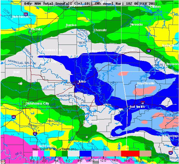
As promised, here is one possible snowfall solution. This basically gives us an indication that heavy snow is very
possible somewhere in the area on Tuesday and especially Wednesday.
Above freezing temps likely today and Monday. Big storm still poised to affect the area midweek.Temperatures did not bottom out last night and look to break above freezing for a few hours today and tomorrow with litte
to no precipiation expected in the Tulsa area.
A Winter Storm is still set to bein affecting the Tulsa area
Tuesday morning with snow increasing in intensity throughout the afternoon. As of now, I expect most schools to be in session
Tuesday as snow amounts should generally be under an inch through rush hour. The bulk of the snow looks to fall overnight
Tuesday night through late morning Wednesday. 6-12 inches currently looks like very good bet across most of the area.
School are likley to be closed Wednesday and Thursday and even possibly on Friday.
A Winter Storm Watch will likely
be issued for the area this evening or early Monday morning. Please finish up your winter storm preperations today if possible.
For those ready for some nicer weather, which is most of us by now, next Saturday looks pretty good right now with
some sun and high temps in the upper 40's to low 50's.
I'll put up some snowfall graphics with the
next update.
Sun, February 6, 2011 | link
Saturday, February 5, 2011
Light winter mix expected Sunday. Big storm taking shape for midweek.Expect a light mix of precip starting late tonight in the form of very light freezing rain. This will transition
to very light sleet or snow but only a 1/2 or less is expected. Temps will struggle to get above freezing Sunday but might
break through the 32-degree barrier for a couple of hours.
Monday will be another break in the action with temps
again possibly getting above freezing for a brief period.
Tuesday morning looks to bring some light snow with heavy
snow expected during the late afternoon and evening hours and lasting through Wednesday evening. The models are on an upswing
in terms of how much snow the system could bring. Current projections are 8-14 throughout most of eastern Oklahoma with
locally higher amounts. This system shouldn't be as potent as the blizzard of last week but it looks to be very, very significant.
Please begin your preparations now for this Winter Storm as roads will quickly become impassable on Tuesday and
remain treacherous through at least Thursday. If this system brings 6 inches or more, which is likely, expect schools to be
closed from possibly Tuesday through Friday.
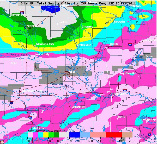
Enjoy today! Sunday's snow amounts seem lighter for Tulsa but it will still be wet.Snowfall amounts may stay light in Tulsa tomorrow but areas along and south of I-40 may get
up to 3 inches.
Sunday's expected snowfall:
The models are ramping up the system for Wednesday and Tuesday. This morning they are showing 6-12 inches of snow
for most of eastern Oklahoma so stayed tuned!
The Winter Storm Warning for Tulsa has been Cancelled.On a related note, Big D got hit with over 5 inches of snow today.

Friday, February 4, 2011
More snow tonight, a brief respite Saturday before the snow returns SundayAnother 1/2 inch or so lof snow ikely tonight.
Saturday will hopefully it make it above freezing but it will be
close. If we can get a little sun, we'll break through the 32 degree mark.
Sunday should be above freezing
but looks wet with 1-3 inches of snow likley for the Tulsa area. Most accumulating snow should occur between 7AM and 7PM.
We get a break from precip Monday before the next system arrives on Tuesday.
Stayed tuned...
Fri, February 4, 2011 | link
Snow ending tonight... more on the wayIt appears 2-4 inches has fallen over
most of the area with another 1 - 1.5 inches possible this evening.
Saturday still looks to possibly get above freezing but Sunday’s potential snowfall has increased according
to the Tulsa NWS with 1-3 inches now expected across the area but it may mix with rain at times with temps 33-36 in the afternoon.
NWS Sunday snow amounts forecast:

Arctic air will again
pour into the area with a high on Monday of only 29 despite mostly sunny skies.
Another significant snow is expected on Tuesday into Wednesday with single digits lows again
in the area. Right now 3-7 inches looks likely across the area but this will likely change as the storm draws nearer.
Stay safe and warm this weekend.
Winter Storm Warning IssuedA Winter Storm Warning has been issued for
Tulsa and surrounding areas. 4-6
inches of snow are expected today in the warning area. The models have not had
a good handle on this particular situation.
Watches and Warnings:
 Expected snowfall for Friday:  Text of Winter Storm Warning: URGENT - WINTER WEATHER MESSAGE NATIONAL WEATHER SERVICE TULSA OK 1131 AM CST FRI FEB 4 2011 ARZ001-002-010-011-019-020-029-OKZ049-053-060>076-050145- /O.UPG.KTSA.WW.Y.0005.000000T0000Z-110205T0300Z/ /O.NEW.KTSA.WS.W.0004.110204T1731Z-110205T0300Z/ BENTON-CARROLL-WASHINGTON AR-MADISON-CRAWFORD-FRANKLIN-SEBASTIAN- PUSHMATAHA-CHOCTAW-TULSA-ROGERS-MAYES-DELAWARE-CREEK-OKFUSKEE- OKMULGEE-WAGONER-CHEROKEE-ADAIR-MUSKOGEE-MCINTOSH-SEQUOYAH-PITTSBURG- HASKELL-LATIMER-LE FLORE- 1131 AM CST FRI FEB 4 2011 Winter Storm Warning in Effect Until 9 PM CST This Evening... the National Weather Service in tulsa has issued a winter storm warning for heavy snow, which is
in effect until 9 PM CST this evening... for the following
counties, * in oklahoma,
cherokee, adair, creek, okfuskee, okmulgee, wagoner, tulsa, rogers, mayes, delaware, pushmataha, choctaw, pittsburg, sequoyah, mcintosh, muskogee, le flore, latimer and haskell. in arkansas, washington,
madison, crawford,
benton, sebastian, carroll and franklin. * this
warning replaces the winter weather advisory that was in effect hazardous weather, * areas of moderate snow with embedded
heavy snow bands will
continue to expand over northeast oklahoma and northwest arkansas through the afternoon. occasional light snow will continue this afternoon across southeast oklahoma
and west central
arkansas, before tapering off by late afternoon. snow will continue through the evening across northeast oklahoma and northwest arkansas. * total snow accumulation of 4 to 6 inches are expected in the warning area. much of southeast oklahoma has
already received 4
to 5 inches and could see an additional inch this afternoon. impacts, * roads, bridges, and overpasses
in the warning area will
remain slick and hazardous. * counties where it was reported that
roads were slick in spots,
choctaw, osage, pawnee, franklin, counties where slick and hazardous roads were reported, pushmataha, washington, nowata, craig, ottawa, tulsa, rogers, mayes,
delaware, creek,
okfuskee, okmulgee, wagoner, cherokee, adair, muskogee, mcintosh, sequoyah, pittsburg, haskell, latimer, leflore, carroll, madison, benton, washington, crawford,
sebastian... definition, * a winter storm warning means significant winter weather is expected or is occurring. precautionary/preparedness actions, * delay travel and stay home if possible until conditions improve. * stay tuned to NOAA weather radio, commercial radio or television for the latest information concerning this
weather event.
additional weather information can also be found at: weather.Gov/tulsa.
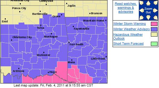
Winter Weather Advisory Issued for TulsaSorry everyone,
The National Weather Service in Tulsa has issued a Winter Weather Advisory for Tulsa, Rogers, Creek and points
south until 9:00 am this evening. 1-2 inches of snow may occur in the advisory area.
I felt the system would weaken
enough to keep accumulations under ½ inch of snow in Tulsa.
Here is the advisory area
and text.
URGENT - WINTER WEATHER MESSAGE NATIONAL WEATHER SERVICE TULSA OK 913 AM CST FRI FEB 4 2011 OKZ060>067-042315- /O.EXA.KTSA.WW.Y.0005.000000T0000Z-110205T0300Z/ TULSA-ROGERS-MAYES-DELAWARE-CREEK-OKFUSKEE-OKMULGEE-WAGONER- 913 AM CST FRI FEB 4 2011 Winter Weather Advisory in Effect Until 9 PM CST This Evening... the
National Weather Service in tulsa has issued a winter weather advisory for snow, which is in effect until 9 PM CST this evening...
for the following counties, * in oklahoma, creek, okfuskee, okmulgee, wagoner, tulsa,
rogers, mayes and
delaware. hazardous weather, * light snow will continue to expand across northeast oklahoma this morning and continue into
the early evening. * 1 to 2 inches of snow accumulation
is expected. impacts, * be prepared for slippery roads and limited visibilities, and use caution while driving. * counties where it was reported that roads were slick in spots, choctaw, osage, pawnee, counties where slick
and hazardous roads
were reported, pushmataha, washington, nowata, craig, ottawa, tulsa, rogers, mayes, delaware, creek, okfuskee, okmulgee, wagoner, cherokee, adair, muskogee,
mcintosh, sequoyah,
pittsburg, haskell, latimer, leflore, carroll, madison, benton, washington, crawford, sebastian... definition, * a winter weather advisory means that
wintry precipitation may
accumulate on roadways. precautionary/preparedness actions, * use extra caution if driving. attempt
to stay on treated
roadways. expect travel delays. * stay tuned to NOAA weather radio,
commercial radio or
television for the latest information concerning this weather event. additional weather information can also be found at: weather.Gov/tulsa. &&
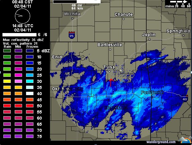
1/2 of snow possible today. Up to 1.5 inches through the weekend.It appears Tulsa may get up to ½
of snow late this morning through afternoon. Here is the current
radar image with the light snow moving north into Tulsa.
Saturday: Will bring temps a couple of degrees above freezing before a light rain/snow mix begins late
and transitions to all snow early Sunday with ½ an inch possible.
Sunday: The light snow should transition back to light rain Sunday afternoon
with temps rising to 35 or so on Sunday. If Saturday and Sunday’s
precipitation were to remain all snow, up to an inch and a half is possible. Once temps fall below freezing Sunday evening,
they will not rise above freezing until next weekend. Monday: Mostly sunny, high
of 25. Tuesday/Wednesday: Another system is poised
to affect the area Tuesday night and Wednesday with another 4-6 inches possible with this system. There are
some indications the heaviest snow will remain east of the area but please continue to be aware of the potential. ______________________________________________________________________________________________________________________________
Thursday, February 3, 2011
More Light Snow Expected Over the Next Several Days3 Day Snowfall Forecast as of 2/03/11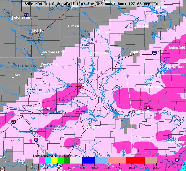
Thu, February 3, 2011 | link
More Snow Possible Over the Next 4-5 Days.There is chance for accumulating snow
tomorrow/tomorrow night but it should be less than ½ inch. There is a chance for ½ inch on Saturday, an inch on Sunday, and another 2-3 inches possible
on Tuesday and Wednesday. Updates will follow.
|